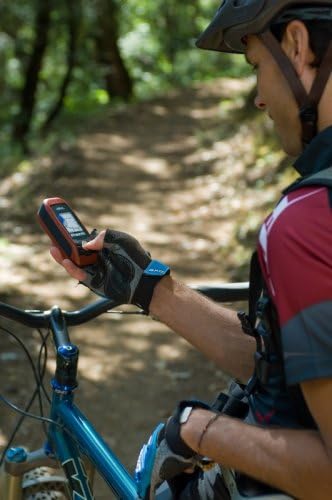
Magellan Triton 300 Waterproof Hiking GPS
|
|
상품가격 상세보기
이벤트보기
|
- 상품상세정보
상품특징
Pre-loaded base maps and compatible third-party maps identify major rivers, lakes, cities, and other geographical boundaries2.2" (5.59 cm) full-color display delivers vivid imagery in the field.Extremely rugged and waterproof to IPX-7 standardsAA batteries provide a readily available power sourceSiRFstarIII¿ delivers the fastest GPS position acquisition in the industry
상품설명
Product Packaging:Standard Packaging Product Description The Triton 300 is so easy to use that its user manual may never make it out of the box. It reinvents handheld GPS by combining exclusive compatibility with National Geographic TOPO!® maps, new Magellan VantagePoint¿ content management software, a rugged, waterproof design, and the essential feature set that outdoor enthusiasts need and expect. Amazon.com Amazon.com Product Description Magellan Triton reinvents handheld GPS. Triton 300 is amazingly easy to use with a smartly designed interface and simple menus that make navigation fun and effortless. The full-color crystal clear display shows all your maps and navigation information in brilliant, easy-to-view graphics. Instantly view all your maps, locations and saved tracks and waypoints using the intuitive scroll pad and direct-access buttons. Unlike other complicated devices that require you to scroll through screen after screen, Triton 300 gets you to the information you want in two or three clicks. The next-generation handheld GPS for precision outdoor navigation. Click to enlarge. Simple menus, instant access buttons, intuitive scroll pad and crystal clear graphics let you navigate with ease. Click to enlarge. See your direction of travel, distance and position of destination, heading, bearing, speed and more on the beautiful graphic compass screen. Click to enlarge. Ready to guide you on any adventure. Click to enlarge. Add detailed maps and applications to the available memory and further enhance your navigation experience. Plus, Triton is the first handheld GPS to offer compatibility with National Geographic TOPO! State series and Weekend Explorer 3D maps. These highly detailed nation-wide topographic maps based on USGS 1:24.000 series quads, offer seamless scalability, multi-layer overlays and much more. Exclusive VantagePoint software enables easy management of maps, user generated content, updates and upgrades on your PC. View saved routes and tracks. Customize them for future trips or create new ones. Triton is designed for precision navigation, offering the fastest GPS positioning acquisition in the industry with the SiRFstarIII chipset. An integrated high-sensitivity antenna provides reliable signal reception even in heavy cloud cover, canyons or deep woods. Built-in signal augmentation reception (WAAS/EGNOS) provides 3-meter accuracy. Rugged and waterproof, the Triton 300 is built to withstand intense use, accidental impact and immersion in one meter of water for up to 30 minutes (IPX-7). It's ready to guide you on any adventure. The advanced features are also easy to use. View the elevation profile for the trail ahead (or any route). See the precise time of sunrise/sunset any day of the year. Get a calculation of the best hunting and fishing time. And much more. Triton is built on the experience of GPS users over nearly 20 years of precision positioning technology from Magellan: the first name in navigation. Magellan Triton 300 Features Amazing ease-of-use Reinventing handheld GPS, simple menus, instant access buttons, intuitive scroll pad and crystal clear graphics let you navigate without the need for a Ph.D. Full-color 2.2" display The large display shows maps, simple menus, navigation screens and other data in brilliant color. Built-in maps Basemap of the 48 contiguous United States, Alaska, and Canada (major highways, city centers, bodies of water and more) plus worldwide geographic boundaries. Access exclusive VantagePoint software Lets you easily manage user generated content, updates and upgrades on your PC. View saved routes and tracks. Customize them for future trips or create new ones. Add detailed maps Upload marine cartography and topographic maps, including the highly-detailed and feature-packed National Geographic TOPO! state series and Weekend Explorer 3D Maps. Compass screen See your direction of travel, distance and position of destination, heading, bearing, speed and more on the beautiful graphic compass screen. 3-meter accuracy SiRFstarIII chipset and integrated multidirectional antennae offer superior GPS accuracy using the Wide Area Augmentation System (WAAS). What's in the Box Triton 300 GPS receiver, Quick reference guide, manual on CD-ROM


2021-11-11 04:36:57